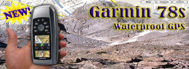
Garmin 78s
| |
|
Php 21,999 
|
The newly designed GPSMAP 78s handheld navigator features a 3-axis tilt-compensated compass, a barometric altimeter and supports Custom Maps, BirdsEye Satellite imagery (subscription required) and photo navigation. Rugged and waterproof, GPSMAP 62s employs a quad helix antenna for unparalleled reception, has a high-speed USB connection, a sleek new design and connects wirelessly to compatible Garmin handhelds.
The unit highlights are:
- microSD slot and substantial internal memory
- rugged, IPX7 waterproof case
- high-sensitivity receiver
- 3-axis, tilt-compensated electronic compass
- barometric altimeter
- paperless geocaching
- USB, serial and external antenna connectors
- improved 160 x 240 pixels 65,000-colour screen
Explore
GPSMAP 78s comes with built-in worldwide basemap, so you can navigate anywhere with ease. And, like the rest of the 78-series, 78s is IPX7 waterproof and even floats in water.
Get your Bearings
GPSMAP 78s has a built-in 3-axis tilt-compensated electronic compass, which shows your heading even when you're standing still, without holding it level. Its barometric altimeter tracks changes in pressure to pinpoint your precise altitude, and you can even use it to plot barometric pressure over time, which can help you keep an eye on changing weather conditions.
Share Wirelessly
With GPSMAP 78s you can share your waypoints, tracks, routes and geocaches wirelessly other compatible device users. Now you can send the location of your favorite fishing spot to a friend to find. Sharing data is easy. Just press ''send'' to transfer your information to similar units.
Get Connected
You've been busy exploring and now you want to store and analyze your activities. With a simple connection to your computer and to the Internet, you can get a detailed analysis of your activities and send tracks to your outdoor device using Garmin Connect™. This one-stop site offers an activity table and allows you to view your activities on a map using Google™ Earth. Explore other routes uploaded by millions of Garmin Connect users and share your experiences on Twitter® and Facebook®. Getting started is easy, so get out there, explore, and share.
Find Fun
GPSMAP 78s supports geocaching GPX files for downloading geocaches and details straight to your unit. By going paperless, you're not only helping the environment but also improving efficiency. GPSMAP 78s stores and displays key information, including location, terrain, difficulty, hints and descriptions, which means no more manually entering coordinates and paper print outs! Simply upload the GPX file to your unit and start hunting for caches. Slim and lightweight, 78s is the perfect companion for all your outdoor pursuits.
GPSMAP 78s: Colorful maps, durable design and buoyant everything a mariner needs.
Garmin 78s: Simple navigation at an affordable price
| General |
| 1 |
Unit dimensions, WxHxD: |
2.6in x 6.0in x 1.2in (6.6 x 15.2 x 3.0 cm) |
| 2 |
Display size, WxH: |
1.6in x 2.2in (4.1 x 5.6 cm); 2.6in diag (6.6 cm) |
| 3 |
Display resolution, WxH: |
160 x 240 pixels |
| 4 |
Display type: |
transflective, 65-K color TFT |
| 5 |
Weight: |
7.7 oz (218.3 g) with batteries |
| 6 |
Battery: |
2 AA batteries (not included); NiMH or Lithium recommended |
| 7 |
Battery life: |
20 hours |
| 8 |
Waterproof: |
Yes (IPX7) |
| 9 |
GPS-enabled: |
Yes |
| 10 |
Floats: |
Yes |
| 11 |
High-sensitivity receiver: |
Yes |
| 12 |
PC interface: |
USB |
| 13 |
RoHS version available: |
Yes |
| 14 |
Preloaded maps: |
No |
| 15 |
Map coverage area: |
North America |
| 16 |
Ability to add maps: |
Yes |
| 17 |
Street Map Compatible: |
Yes |
| 18 |
Topographic Map Compatible: |
Yes |
| 19 |
Marine Software Compatible: |
Yes |
| 20 |
Bluechart g2 Map Compatible: |
Yes |
| 21 |
Bluechart g2 Vision Map Compatible: |
No |
| 22 |
Built-in memory: |
1.7 GB |
| 23 |
Accepts data cards: |
microSD data card |
| 24 |
Waypoints/favorites/locations: |
2000 |
| 25 |
Additional: |
High Speed USB |
| 26 |
Garmin Connect™ compatible (online community where you analyze, categorize and share data): |
Yes |
| 27 |
Widescreen |
No |
| 28 |
Custom Maps Compatible |
Yes |
| Automotive |
| 29 |
Routes: |
200 |
| 30 |
Basemap: |
Yes |
| 31 |
Voice prompts (e.g. "Turn right in 500 ft."): |
No |
| 32 |
Speaker Location: |
Internal Buzzer |
| 33 |
Speaks street names (e.g. "Turn right ON ELM STREET in 500 ft.") : |
No |
| 34 |
Speech recognition (navigate with voice commands): |
No |
| 35 |
3D map view: |
No |
| 36 |
Automatic routing (turn by turn routing on roads): |
Yes |
| 37 |
Auto sort multiple destinations (provides most direct route): |
No |
| 38 |
Auto re-route (fast off-route and detour recalculation): |
No |
| 39 |
Choice of route setup (faster time, shorter distance, off road): |
Yes |
| 40 |
Route avoidance (avoid highways, tolls etc.): |
No |
| 41 |
Custom POIs (ability to add additional points of interest): |
Yes |
| 42 |
Hands-free calling with Bluetooth® wireless technology: |
No |
| 43 |
FM traffic compatible: |
No |
| 44 |
XM® Navtraffic (includes basic weather) & Radio for U.S. compatible: |
No |
| 45 |
MSN® Direct for U.S. compatible: |
No |
| 46 |
Where Am I? feature (find closest hospitals, police & gas stations, nearest address & intersection): |
No |
| 47 |
Car locator feature (marks position when removed from windshield mount): |
No |
| 48 |
MP3 player: |
No |
| 49 |
Audio book player: |
No |
| 50 |
Picture viewer: |
No |
| 51 |
Configurable vehicle icons (select car-shaped icons for map navigation): |
No |
| 52 |
World travel clock, currency & measurement converter, calculator: |
No |
| 53 |
Touchscreen: |
No |
| 54 |
Qwerty or ABC keyboard (choose keyboard layout): |
No |
| 55 |
Antenna Type: |
Internal |
| 56 |
External Antenna Jack: |
MCX |
| 57 |
Remote control: |
No |
| 58 |
FM transmitter: |
No |
| 59 |
Headphone jack/audio line-out: |
No |
| 60 |
Audio/video input/output: |
No |
| 61 |
Dead reckoning: |
No |
| 62 |
Garmin Lock™ (anti-theft feature): |
No |
| 63 |
Automotive-friendly: |
No |
| 64 |
Motorcycle-friendly: |
No |
| 65 |
Lane Assist |
No |
| 66 |
Data Services with Bluetooth Technology |
No |
| 67 |
Speed Limit Indicator |
No |
| 68 |
Lifetime Traffic |
No |
| 69 |
Lifetime Maps Included |
No |
| Outdoor |
| 70 |
Track log: |
10,000 points, 200 saved tracks |
| 71 |
Electronic compass: |
Yes (3-axis) |
| 72 |
Barometric altimeter: |
Yes |
| 73 |
Hunt/fish calendar: |
Yes |
| 74 |
Sun and moon information: |
Yes |
| 75 |
Tide tables: |
Yes |
| 76 |
Area calculation: |
Yes |
| 77 |
Geocaching mode: |
Yes |
| 78 |
Outdoor GPS games: |
Yes |
| 79 |
Unit-to-unit transfer (shares data wirelessly with similar units): |
Yes |
| 80 |
Photo navigation (navigate to geotagged photos) |
Yes |
| Marine |
| 81 |
Portable |
Yes |
| 82 |
Marine Auto Guidance |
No |
| 83 |
Radar compatible |
No |
| 84 |
Sonar compatible |
No |
| 85 |
CANet® compatible |
No |
| 86 |
Marine Network™ compatible |
No |
| 87 |
Supports AIS (tracks target ships' position) |
No |
| 88 |
Supports DSC (displays position data from DSC capable VHF radio) |
No |
| 89 |
Audible alarms |
Yes |
| 90 |
XM WX Weather & Radio for U.S. compatible |
No |
| 91 |
NMEA input/output |
Yes (NMEA 0183) |
| 92 |
Dual-beam sonar capable |
No |
| 93 |
Dual-frequency sonar capable |
No |
| 94 |
Split-screen zoom |
No |
| 95 |
A-scope (real time display of fish passing through transducer beam |
No |
| 96 |
Whiteline (indicates hard or soft bottom) |
No |
| 97 |
Water temperature sensor included |
No |
|
|